


Hiking the East Rosebud Trail to Rainbow Lake in the Beartooth Mountains, Montana
Distance: 17.1 miles / 27.5 km
With its countless glaciers, towering peaks, and lakes filled with trout fed by glacial streams and waterfalls, there are truly so many reasons to love the Absaroka Beartooth Range—which is, without a doubt, my favorite mountain range in the lower 48.
Furthermore, the East Rosebud Trail, also known as 'The Beaten Path,' is arguably the most scenic backpacking trip in Montana’s Beartooth Mountains!
That being said, since my friend and I didn’t have the time for the full thru-hike, this article is only about the East Rosebud Trail as far as Rainbow Lake.

My Print - Rainbow Lake
Rainbow Lake Trailhead Parking
Parking for the East Rosebud Trailhead is located at the very end of East Rosebud Road in Roscoe, Montana.
That being said, the last few miles on East Rosebud Road can be a bit long and bumpy on the dirt road to get there, but it should generally be passable for most 2WD vehicles, granted that the road is snow-free.
Google Maps Directions: East Rosebud Trailhead
Hiking Checklist - Beartooths
Obviously, for camping, you will need general backpacking gear. For this reason, I wrote a separate post about what backpacking gear is worth the money, from my experience, and what the best alternatives are to save you money.
Read My Separate Post: Best Ultralight Backpacking Gear
In addition, here is a complete list of must-have things that you will want for any hike in the Beartooth Mountains, including bear spray, as the Beartooth Range is both black and grizzly bear territory.
Bear Spray & Holster - If you aren’t flying, don’t rent bear spray! It’s a waste of money. Prepare ahead of time by buying your own, as this may be one of the most important items on this list.
Osprey 3L Water Bladder - The Osprey 3L water bladder is the most universal hiking and backpacking water bladder on the market, and it’s my go-to because of the slide-off seal that allows it to be quickly filled from the top. Additionally, individual parts are easily replaceable, such as the bite valve.
Blister / Heel Protectors - I swear by these cheap, amazing heel protectors to prevent blisters for nearly every kind of hiking and backpacking that I do!
Black Diamond Headlamp - Personally, I recommend the Black Diamond Storm because it is one of the brightest, lightest, and longest-lasting headlamps on the market—and trust me, the weight-to-battery-life ratio really does matter!
Hiking / Trail Running Shoes - Depending on the type of trail, I prefer to use either the Keen Targhee for longer, more rugged hiking or the HOKA Zinal Trail-Running Shoe for lighter, less intense trails. In either case, both have been amazing to me for many years across countless environments, and both can be found in men’s and women’s sizes. - (Men’s Keen / Women’s Keen) (Men’s HOKA / Women’s HOKA)
Waterproof Rain Shell - You never know when it may rain, and I’ve learned over the years that a rain shell is far better than a rain jacket. By this, I mean that it’s best to have something that the water will roll right off of, which is why I recommend the Patagonia Torrentshell 3L available in both men’s and women’s sizes.
Sun Shirt w/ Hood - A quality sun shirt can be your best friend on a trail with minimal shade, which can be found in both men’s and women’s sizes.
Head Bug Net - Deciding whether to pack a bug net should be based around the time of year that you’re visiting, meaning that as long as temperatures remain steadily above the mid-50s, the bugs can be brutal!
Wag bag - In some backcountry areas, all human waste is required to be packed out using one of these bags. When this is the case, plan on packing one bag for every night that you will be there, as having to reuse a bag twice is never a good idea.
High SPF Sunscreen - Packing high-SPF sunscreen is a must for long days outside!


Hiking the Rainbow Lake Trail
Beginning from the East Rosebud Trailhead in the Custer-Gallatin National Forest, the hike begins up one of America’s newest federally protected rivers under the Wild and Scenic Act.
In any case, the hike up East Rosebud Creek to Rainbow Lake is about as stunning as a backcountry trip can be!
By this, I mean that the higher you hike up East Rosebud to Elk Lake and beyond, the more the canyon you’re in narrows until you’re surrounded by towering granite walls on both sides!
That being said, there are a number of stream crossings to navigate before Rimrock Lake, which can be tricky to keep your shoes dry—especially when the snowmelt is more significant in the early summer season.
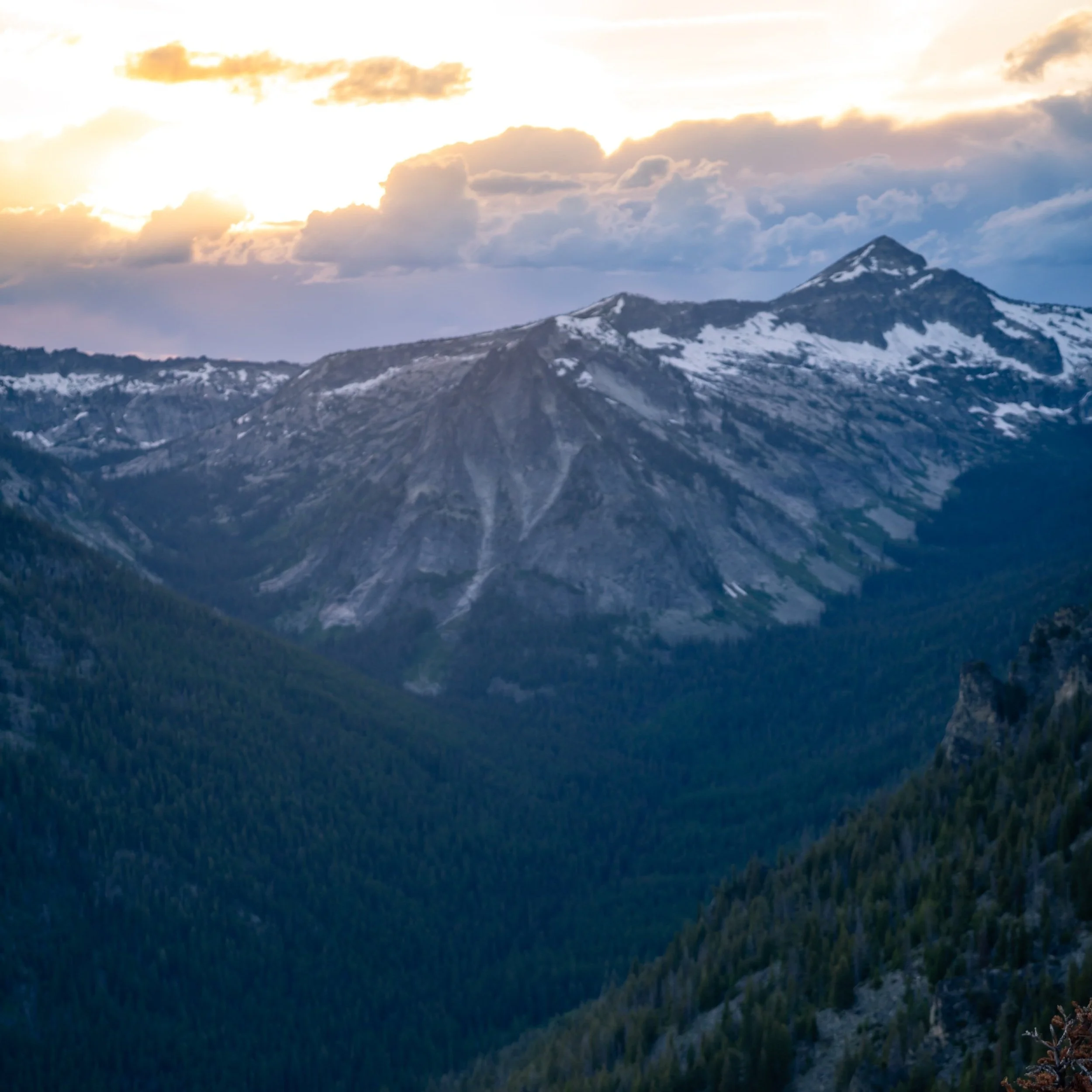
Past Elk Lake, the East Rosebud Trail gains somewhere between 800-900 ft. (244-274 m) of elevation on the switchbacks leading up to Rimrock Lake.
It’s at this point that the canyon really starts to narrow, which, in my opinion, was the most beautiful section of the trail prior to Rainbow Lake.

My Print - East Rosebud Trail
Rimrock Lake
The East Rosebud Trail approaches Rimrock Lake on the left (east) side before descending and crossing over East Rosebud Creek at the mouth of the lake.
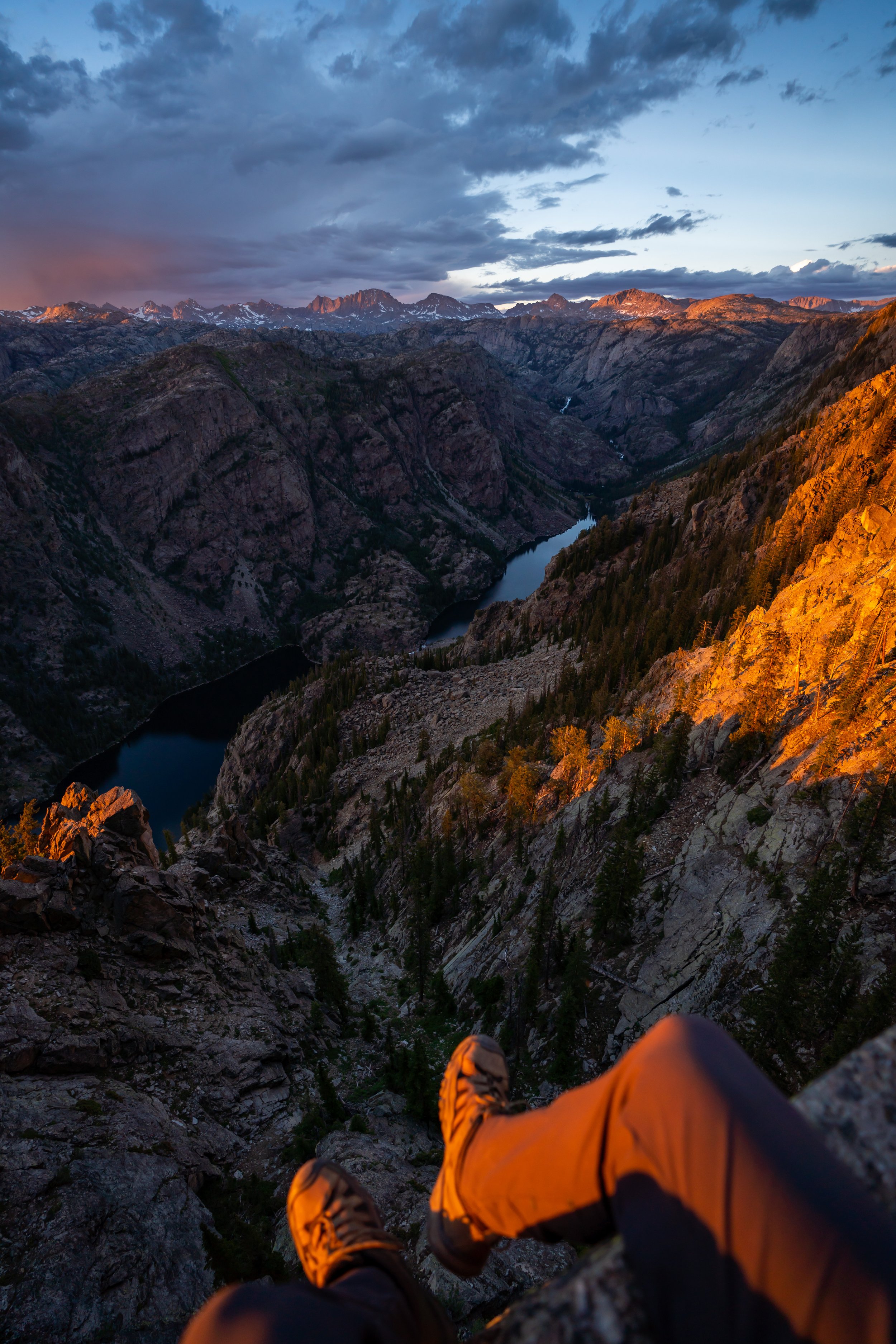
Then, past Rimrock Lake, the trail will gain roughly another 200 ft. (61 m), which will be the first time you get a view of Rainbow Lake at about 7.8 miles (12.6 km) into the hike.
Rainbow Lake
From the start of Rainbow Lake, it’s only another 0.8 miles (1.3 km) to reach the Rainbow Lake campsites, located at the far (south) end of the lake.
Rainbow Lake Campsite
In total, the East Rosebud Trail to the Rainbow Lake campsite is roughly 8.6 miles (13.8 km) each way.
That being said, make sure that you are aware of the current fire restrictions, as different areas of the Beartooths tend to follow different rules.
'The Beaten Path' to Clarks Fork
As previously mentioned, I only had the opportunity to hike as far as Rainbow Lake, but one of the coolest things about starting from the East Rosebud Trailhead is that you can thru-hike it all the way to the Beartooth Highway!
From Rainbow Lake, the East Rosebud Trail will climb to Lake at Falls, past a few more lakes until it reaches the 10,000 ft. (3,048 m) mark at Fossil Lake. Then, the trail begins descending down to the Beartooth Highway on the Russel Creek Trail, where the hike ends at the Clarks Fork Trailhead.
Overall, 'The Beaten Path' is a stunning 26-mile (41.8 km) one-way hike if you choose to thru-hike it from either East Rosebud or the Clarks Fork Trailhead.
However, the benefit of starting at the Clarks Fork Trailhead over East Rosebud is that you will only have to climb about 2,000 ft. (610 m) to the trail’s crest, whereas by hiking from the East Rosebud Trailhead, you will start lower and have to climb just under 4,000 ft. (1,219 m) to the trail’s crest at Fossil Lake.
All said, there are a variety of Beartooth shuttle services worth looking into, so that you can thru-hike 'The Beaten Path' and have a ride back to either trailhead.
AllTrails: 'The Beaten Path'
Additional Early Season Gear
Depending on the winter snowpack, upper-elevation areas can be covered in snow into the middle of July or even early August.
For this reason, micro-spikes may be a necessity across many upper-elevation areas throughout the Beartooths, like 'The Beaten Path.'
I personally use the Yaktrax below.


More Mountain West Adventures
If you’re interested in reading about some more amazing Mountain West adventures, check out my separate posts below!


Best Way to Find Places to Stay!
Wherever I travel, I love to start my search for places to stay on VRBO.
Even if I don’t end up booking through them, I think it’s one of the best ways to see what’s in the area!

Washington
Best Way to Book Rental Cars!
I travel quite a bit, and I know firsthand that finding a good rental car deal can be a challenge, but that’s why I recommend comparing all of your options with Discover Cars.
In short, Discover Cars is a well-known, reputable business that allows you to search for the best deal across companies, and they have the best full-refund cancellation policy I’ve ever seen, valid up to 72, or sometimes even 48, hours prior to your reservation!
Book Here: Discover Cars

Discover Cars!
Safety
Now more than ever, it’s commonly agreed upon that Grizzly Bears can be found in all mountain ranges across Montana, as their range only continues to expand between the Greater Yellowstone Ecosystem and Glacier National Park.
Therefore, it’s important to hike with bear spray and know how to react in the event of a Black or Grizzly Bear encounter.
Aside from wildlife, Montana, like any Mountain West state, is known for its violent afternoon thunderstorms, which are more typical in the warmer summer months than other times of the year.
That said, it’s important to check the local forecast before setting off on any adventure, as lightning strikes are not uncommon in and near mountain ranges across the West. I have personally been knocked to the ground by a strike that hit near me in the past, and I confidently say that it’s an experience you don’t want to live through. This is why I highly recommend checking Mountain Forecast for any high-elevation adventures you may be interested in—especially when climbing a summit.
Finally, Montana is one of the more glaciated states in the lower 48, and I say this to remind that all skills related to glacier travel are necessary whenever attempting an adventure as such.


Disclaimer
All information provided on this blog is for informational purposes only and is not intended to be a substitute for information or advice from qualified professionals or managing agencies.
Noah Lang Photography LLC makes no representations or warranties regarding the accuracy or completeness of the information provided here, and readers should use their own discretion, judgement, and seek professional advice where it is appropriate.
Furthermore, Noah Lang Photography LLC shall not be held responsible for any injuries, lost individuals, or legal issues arising from the use of information provided on this website, and if applicable, the above safety disclaimer should be referenced to provide a generic overview of the risks involved.
All said, the content on this blog is for the sole use of Noah Lang Photography LLC, and unauthorized use or reproduction of this content is strictly prohibited.
Disclosure
This post is not sponsored.
However, some of the links in this post are affiliate links, which means that I may earn a small commission if a purchase is made through one of those links. This commission comes at no additional cost to you, and I only recommend products that I personally use and believe will add value to my readers. Thank you for your support, which enables me to continue creating more!
To read the full privacy policy, click here.

About This Blog
Noah Lang Photography, also known as @noahawaii, is 100% reader-supported!
I do not accept guest articles or sponsored content of any kind on my blog, which is why, if you enjoy the outdoor and travel content I create, please consider buying me a coffee!
I appreciate your support, which helps me continue to keep this blog alive!