


Hiking the Panoramic Point Trail in Kings Canyon National Park
Distance: 0.5 miles / 0.8 km
The Panoramic Point Trail is one of the best, easiest, and often overlooked adventures in the Grant Grove District of Kings Canyon National Park, especially when compared to nearby day hikes like the busy General Grant Tree Trail.
That being said, I highly recommend hiking the Panoramic Point Trail if you’re visiting Kings Canyon but don’t have time to drive Highway 180 to the Cedar Grove District of the park.
I say this because the views from Panoramic Point overlook the canyon and extend far beyond to some of the highest summits in the lower 48, making the Panoramic Point Loop one of the best day hikes to truly get a sense of just how deep and expansive Kings Canyon National Park truly is!
U.S. National Park Pass
Did you know that the same America the Beautiful Pass that grants access to all 63 U.S. National Parks can be purchased in advance at REI?
Yes, you can save time when you arrive by purchasing your National Park pass, along with your other outdoor gear, at REI before traveling to the park!


Panoramic Point Trailhead Parking
The Panoramic Point Trailhead is located at the very top of Panoramic Point Road, about 2.3 miles (3.7 km) up the hill from Grant Grove Village.
That being said, the road past the John Muir Lodge can be a bit windy and narrow, which is why it’s important to take your time, as there are a number of blind turns to look out for.
Google Maps Directions: Panoramic Point Trailhead
Hiking Checklist - Sequoia-Kings Canyon
Here is a complete list of must-have things that you will want for any hike in Sequoia and Kings Canyon National Park.
That being said, bear spray is purposefully excluded from this list because, while the Sierra Nevadas are home to a large black bear population, bear spray is not allowed in either Sequoia or Kings Canyon National Park.
Osprey 3L Water Bladder - The Osprey 3L water bladder is the most universal hiking and backpacking water bladder on the market, and it’s my go-to because of the slide-off seal that allows it to be quickly filled from the top. Additionally, individual parts are easily replaceable, such as the bite valve.
Blister / Heel Protectors - I swear by these cheap, amazing heel protectors to prevent blisters for nearly every kind of hiking and backpacking that I do!
Black Diamond Headlamp - Personally, I recommend the Black Diamond Storm because it is one of the brightest, lightest, and longest-lasting headlamps on the market—and trust me, the weight-to-battery-life ratio really does matter!
Hiking / Trail Running Shoes - Depending on the type of trail, I prefer to use either the Keen Targhee for longer, more rugged hiking or the HOKA Zinal Trail-Running Shoe for lighter, less intense trails. In either case, both have been amazing to me for many years across countless environments, and both can be found in men’s and women’s sizes. - (Men’s Keen / Women’s Keen) (Men’s HOKA / Women’s HOKA)
Waterproof Rain Shell - You never know when it may rain, and I’ve learned over the years that a rain shell is far better than a rain jacket. By this, I mean that it’s best to have something that the water will roll right off of, which is why I recommend the Patagonia Torrentshell 3L available in both men’s and women’s sizes.
High SPF Sunscreen - Packing high-SPF sunscreen is a must for long days outside!


Hiking the Panoramic Point Trail
The Panoramic Point Trail follows a paved path from the trailhead to both overlooks, making it one of the most accessible day hikes in Kings Canyon National Park.
Panoramic Point Loop Trail
After 0.1 miles (0.2 km), the Panoramic Point Trail splits into a loop that leads to both overlooks along the upper trail.
Personally, I chose to go right, which is also the most direct route to reach the beginning of the Park Ridge Trail, starting at the Park Ridge Overlook.
Panoramic Point-Park Ridge Junction
Just before the Panoramic Point Loop reaches the top, the trail splits once again into the route that leads to the Park Ridge Overlook and the beginning ridge trail, as well as the return loop that leads down to Panoramic Point.
Here, I chose to go right toward the Park Ridge Overlook.
Park Ridge Overlook
The Park Ridge Overlook is the uppermost viewpoint on the Panoramic Point Trail, which is also where it leaves behind the paved path and begins the 2.4-mile (3.9 km) hike up Park Ridge to the Fire Lookout at the summit.
Read My Separate Post: Park Ridge Trail
Panoramic Point-Park Ridge Junction
After spending some time at the Park Ridge Overlook, I continued back down to the main Panoramic Point Overlook, which is the best place to learn more about what you’re looking at in the distance.
At this split, go right to reach Panoramic Point shortly ahead.
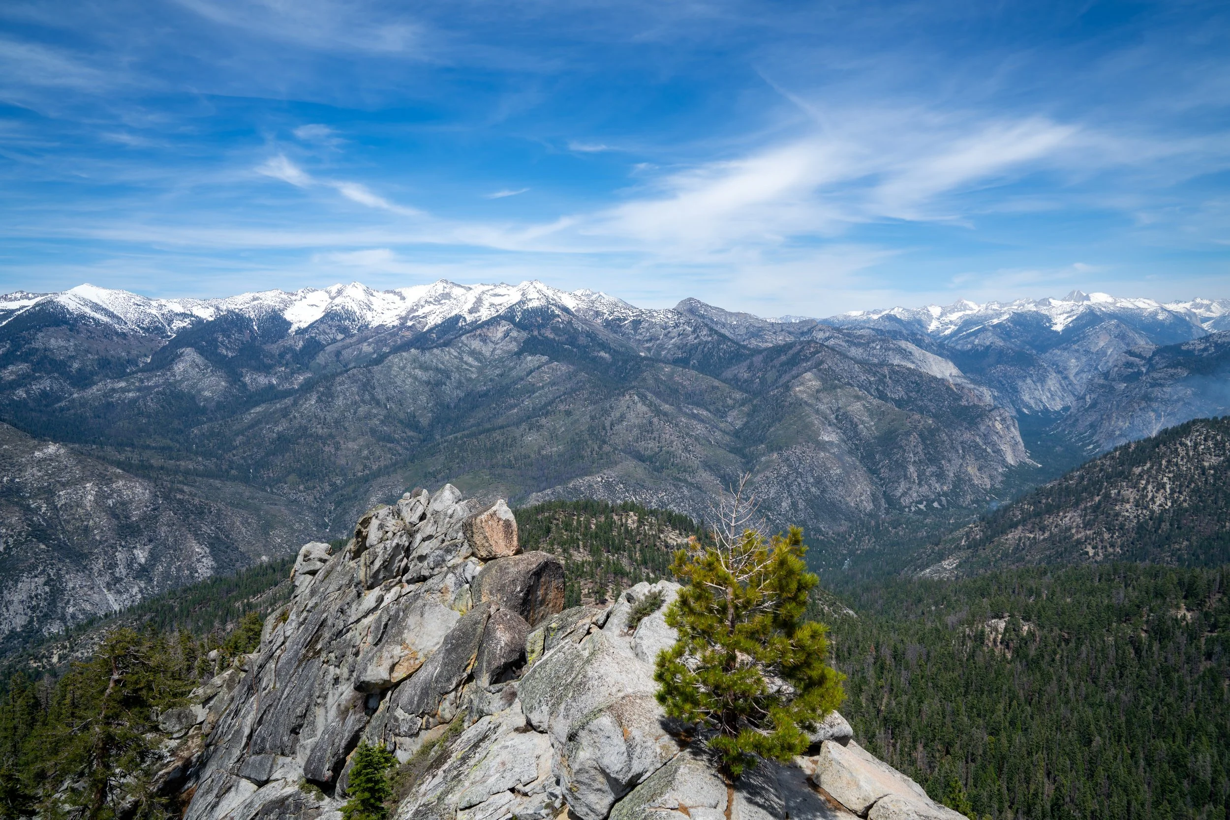
Panoramic Point
The Panoramic Point Overlook is the best place in Kings Canyon National Park to enjoy an upper vantage point of Kings Canyon from above.
In addition, notable summits, like the glaciated North Palisade Peak, can be seen in the distance, which is one of several California summits that stands at over 14,000 ft (4,267 m), like the much more renowned Mt. Whitney to the south.
Once back on the trail, the Panoramic Point Loop simply makes its way back down to the beginning.
Panoramic Point Loop Junction
This is where the Panoramic Point Loop Trail returns to the start, with just 0.1 miles (0.2 km) remaining to return the trailhead.
More Sequoia-Kings Canyon Adventures
If you’re interested in reading about some more amazing adventures within Sequoia & Kings Canyon National Park, check out my separate posts below!
Sequoia National Park


Kings Canyon National Park


Best Way to Find Places to Stay!
Wherever I travel, I love to start my search for places to stay on VRBO.
Even if I don’t end up booking through them, I think it’s one of the best ways to see what’s in the area!

Washington
Best Way to Book Rental Cars!
I travel quite a bit, and I know firsthand that finding a good rental car deal can be a challenge, but that’s why I recommend comparing all of your options with Discover Cars.
In short, Discover Cars is a well-known, reputable business that allows you to search for the best deal across companies, and they have the best full-refund cancellation policy I’ve ever seen, valid up to 72, or sometimes even 48, hours prior to your reservation!
Book Here: Discover Cars

Discover Cars!
Safety
Most importantly, Sequoia and Kings Canyon National Park is bear country, and while hiking in black bear territory generally presents less of a risk as opposed to hiking with grizzlies, it‘s important to never get complacent.
That being said, bear spray is not allowed within either Sequoia or Kings Canyon National Park, but storing your food properly, both on your person and in your vehicle, is not only necessary but required. For this reason, always keep your food and trash with you, and follow these basic rules from the NPS with regards to food in your vehicle.
On a different note, there is one venomous snake found in both parks known as the Western Rattlesnake, and surprisingly, I have encountered it many times, both in dry landscapes and in the meadows of both parks.
Finally, during winter months, you may be required to carry tire chains or have them on your vehicle before entering either park. In addition, micro-spikes may be necessary to stay safe on certain trails, such as Little Baldy and many others during the early and late summer season.
As always, find the most up-to-date information and conditions on the official Sequoia-Kings Canyon National Park website.
National Park Service: Sequoia & Kings Canyon National Park


U.S. National Parks Pass
Did you know that the same America the Beautiful Pass that grants access to all 63 U.S. National Parks can be purchased in advance at REI?
Yes, you can save time when you arrive by purchasing your National Park pass, along with your other outdoor gear, at REI before traveling to the park!
More U.S. National Parks
If you’d like to read more about some of my best recommendations when visiting other U.S. National Parks, check out some of my other posts below!


Disclaimer
All information provided on this blog is for informational purposes only and is not intended to be a substitute for information or advice from qualified professionals or managing agencies.
Noah Lang Photography LLC makes no representations or warranties regarding the accuracy or completeness of the information provided here, and readers should use their own discretion, judgement, and seek professional advice where it is appropriate.
Furthermore, Noah Lang Photography LLC shall not be held responsible for any injuries, lost individuals, or legal issues arising from the use of information provided on this website, and if applicable, the above safety disclaimer should be referenced to provide a generic overview of the risks involved.
All said, the content on this blog is for the sole use of Noah Lang Photography LLC, and unauthorized use or reproduction of this content is strictly prohibited.
Disclosure
This post is not sponsored.
However, some of the links in this post are affiliate links, which means that I may earn a small commission if a purchase is made through one of those links. This commission comes at no additional cost to you, and I only recommend products that I personally use and believe will add value to my readers. Thank you for your support, which enables me to continue creating more!
To read the full privacy policy, click here.

About This Blog
Noah Lang Photography, also known as @noahawaii, is 100% reader-supported!
I do not accept guest articles or sponsored content of any kind on my blog, which is why, if you enjoy the outdoor and travel content I create, please consider buying me a coffee!
I appreciate your support, which helps me continue to keep this blog alive!