Hiking the Pēpēʻōpae Bog Trail in the Kamakou Preserve on Molokai, Hawaiʻi
Distance: 2.0 miles / 3.2 km
The Pēpēʻōpae Bog Trail in the Kamakou Preserve on Molokai is arguably the best day hike across all the islands!
That being said, the Pēpēʻōpae Bog is not like most Hawaiʻi trails, meaning it requires some planning to experience this one-of-a-kind trail—most notably, good weather, proper gear preparation, and potentially a guided hike through The Nature Conservancy.
By all this, I mean that the Kamakou Preserve is one of the most remote publicly accessible areas on Molokai, and the long, rough 4WD road will reflect the same. This is why rental car companies do not recommend off-roading on Molokai—especially in the Kamakou Preserve—as there are no facilities or cell phone service of any kind.
In addition, I only recommend hiking the Pēpēʻōpae Bog Trail on the clearest of clear days since the journey to the trailhead is so long. Even then, the clouds will still dictate whether you get to see the incredible view at Pelekunu Valley. I say this because clear weather in Kaunakakai doesn’t mean the weather will be clear in the mountains. To know for sure, I recommend finding a good vantage point of the mountains, which you should be able to see on the short drive to the access road north of Kaunakakai mentioned below. If the mountains don’t look clear on this drive, I recommend saving Pēpēʻōpae for another day.
Finally, and perhaps most importantly, the Kamakou Preserve is one of the most pristine native forests in all of Hawaiʻi. There are truly few places across the islands that resemble such a highly native, biodiverse landscape. This is important to keep in mind because The Nature Conservancy is working hard to prevent the spread of Rapid ʻŌhiʻa Death (ROD), a highly invasive fungal disease that has been decimating Hawaiʻi’s most prominent native tree,ʻŌhiʻa lehua. Therefore, The Nature Conservancy asks all hikers to clean their gear or spray 70% rubbing alcohol before entering the Kamakou Preserve.
For all these reasons, the easiest and most responsible way to hike the Pēpēʻōpae Bog Trail—especially for out-of-state visitors—is to set up a guided hike with The Nature Conservancy using the information below.
The Nature Conservancy: (808) 954-6581 / hike_molokai@tnc.org
How to Get to the Pēpēʻōpae Bog Trailhead?
The Kamakou Preserve and the Pēpēʻōpae Bog Trail is only accessible with a 4x4 vehicle. There’s absolutely no way a low-clearance 2WD vehicle would make it.
Now, granted that you have a 4x4 vehicle, navigating to the trailhead is the next most important task, and it’s not as straightforward as simply pulling up the trailhead directions linked in the section below and following your GPS. In my experience, Google Maps does not know how to navigate to the trailhead, as it will constantly try to take you the wrong way through private roads while re-routing you, even when you’re on the correct road.
Therefore, instead of simply entering the Pēpēʻōpae Trailhead directions into a GPS, drive to the start of the Department of Land and Natural Resources (DLNR) access road linked below.
Google Maps Directions: Maunahui-Makakupaʻia (Access Road)
Maunahui-Makakupaʻia Access Road
From the start of the 4WD access road, it’s a long 11.8-mile (19.0 km) drive into the Molokai Forest Reserve to get to the Pēpēʻōpae Bog Trailhead, which will take anywhere between 1-2 hours each way.
If you’re using a GPS, my biggest advice is to keep going straight and never make any turns off the main access road heading into the mountains.
That said, Google Maps will likely and repeatedly try to tell you turn off the public access road and onto the private land paralleling the road, as it thinks there’s a faster route through the Molokai Ranch.
For this reason, I recommend download the AllTrails access road map onto your phone and navigating using this, as opposed to using any GPS.
Molokai Forest Reserve
Eventually, the Maunahui-Makakupaʻia Access Road will enter into the Molokai Forest Reserve, which is probably the nicest mental checkpoint that you’re on the right road after passing through many miles of private land down below.
ʻIliahi (Sandalwood) Pit
Maunahui-Makakupaʻia will then pass by the culturally significant ʻIliahi Pit, also known as the Sandalwood Pit, which I recommend checking out either on your way up or down because it’s an interesting place to learn about and see a small part of Hawaiʻi’s history—a bit of a dark history at that.
What is Story of ʻIliahi (Sandalwood) in Hawaiʻi?
In short, ʻIliahi, or Sandalwood as it’s known as in other places around the world, is one of the most valuable woods for its oil and fragrance properties, and Hawaiʻi is home to a third of all Sandalwood species in the world.
On account of its value, the Hawaiian Kingdom began exporting Sandalwood in the late 1700s and early 1800s, primarily to China, as a way repay debts that it had been accruing.
This practice was unsustainable, and the ʻIliahi trade collapsed as many of the Hawaiian Sandalwood species were over-harvested to the point of extinction.
As for the ʻIliahi Pit, this hole in the ground was supposed to replicate a ship’s hold so that Hawaiians knew how much ʻIliahi would fit on one ship from where it was gathered up here in the forest before being transported down the mountain.
Waikolu Valley Lookout
Shortly past the ʻIliahi Pit, the next stop on the access road is the Waikolu Valley Lookout, and I highly recommend pulling over to check out the view, as the lookout is easily one of the most beautiful places on Molokai!
However, another reason I recommend walking over to the overlook is that you never know if you’ll be able to see the view because of the clouds. For this reason, I suggest checking it out on both your way up and down from Pēpēʻōpae, in order to better your chances.
Kamakou Preserve
Immediately past the Waikolu Valley Overlook, the access road enters the Kamakou Preserve.
At this point, there’s less than 2.0 miles (3.2 km) of driving in order to reach the Pēpēʻōpae Bog Trailhead, but in my experience, this is always the wettest and muddiest part of the drive.
If you didn’t need to put your car in 4WD up to this point, I would do it for these remaining miles.
Pēpēʻōpae Bog Trailhead Parking
When you finally make it to Pēpēʻōpae, the road will split, which is where the Pēpēʻōpae Bog Trailhead will be found to the left, a short distance off the main road.
This is all to say, I hope that my long description will show that driving to the Pēpēʻōpae Bog is not as straightforward as simply following the Google Maps GPS directions linked below.
Plan accordingly, be aware know that you’re likely going to have to accept breaking your rental contract to off-road, look for good weather, and most of all, responsibly clean your gear before entering the preserve!
Google Maps Directions: Pēpēʻōpae Bog Trailhead
My Hawaiʻi Hiking Checklist
Osprey 3L Water Bladder - The Osprey 3L water bladder is the most universal hiking and backpacking water bladder on the market, and it’s my go-to because of the slide-off seal that allows it to be quickly filled from the top. Additionally, individual parts are easily replaceable, such as the bite valve.
Blister / Heel Protectors - I swear by these cheap, amazing heel protectors to prevent blisters for nearly every kind of hiking and backpacking that I do!
Black Diamond Headlamp - Personally, I recommend the Black Diamond Storm because it is one of the brightest, lightest, and longest-lasting headlamps on the market—and trust me, the weight-to-battery-life ratio really does matter!
Hiking / Trail Running Shoes - Depending on the type of trail, I prefer to use either the Keen Targhee for longer, more rugged hiking or the HOKA Zinal Trail-Running Shoe for lighter, less intense trails. In either case, both have been amazing to me for many years across countless environments, and both can be found in men’s and women’s sizes. - (Men’s Keen / Women’s Keen) (Men’s HOKA / Women’s HOKA)
Waterproof Rain Shell - You never know when it may rain, and I’ve learned over the years that a rain shell is far better than a rain jacket. By this, I mean that it’s best to have something that the water will roll right off of, which is why I recommend the Patagonia Torrentshell 3L available in both men’s and women’s sizes.
High SPF Sunscreen - Packing high-SPF sunscreen is a must for long days outside!
Hiking the Pēpēʻōpae Bog Trail
After the long, slow journey to get here, I think it’s nice to know that the Pēpēʻōpae Bog Trail is a very easy hike, as the entire trail follows a series of boardwalks from the ungulate exclusion fence to the Pelekunu Valley Overlook at the end of the trail.
If you’re familiar with hikes on Oʻahu, Pēpēʻōpae reminds me of the Mt. Kaʻala summit bog, but it’s simply a bit longer.
That being said, I would still anticipate coming off the hike muddy with soaked shoes, as the boardwalk will sink into the bog in unsuspecting places.
Notice
The Kamakou Preserve, where Pēpēʻōpae is located, is not only one of the most pristine native forests on Molokai but all of Hawaiʻi.
To put it into context, the vast majority of the Maunahui-Makakupaʻia Access Road ascends through a sick, dead, and dying Hawaiian forest, which is true for most areas around Molokai.
However, these high-elevation wet forests, especially here on Molokai, are so pristine and intact that I ask that you please clean off all your hiking gear before hiking Pēpēʻōpae to prevent the spread of invasive species. Please spray off any mud on your shoes, and hike in clean clothes only.
Mahalo!
That being said, since the drive is so long and the Pēpēʻōpae Bog hike is so short, I highly recommend that you take your time to enjoy the native forest.
Few trails in Hawaiʻi traverse such a beautiful native forest where the vast majority of the species can only be found in Hawaiʻi, such as Paʻiniu, shown below.
To go even further, this particular native species is endemic solely to Molokai and not found on any of the other Hawaiian Islands.
When the Pēpēʻōpae Bog Trail reaches the clearing, I think it’s a good time to look up toward the ridgeline to see what the clouds are doing.
On this day, the entire summit was socked in, but even if this is true during your visit, keep going, and you’ll see why later in this post.
In the middle of the clearing, the Pēpēʻōpae Bog Trail makes a hard right to continue toward Pelekunu Valley.
Then, when the trail re-enters the forest, it won’t pop out again until the Pelekunu Valley Overlook at the end of the trail.
Toward the end of the bog, the Pēpēʻōpae Trail will parallel this small fence line, which is a nice sign that you’re getting close!
Pēpēʻōpae (Pelekunu Valley Overlook)
After about 1.0 miles (1.6 km) of hiking through the Pēpēʻōpae Bog, the boardwalk finally ends at Pēpēʻōpae, also called the Pelekunu Valley Overlook.
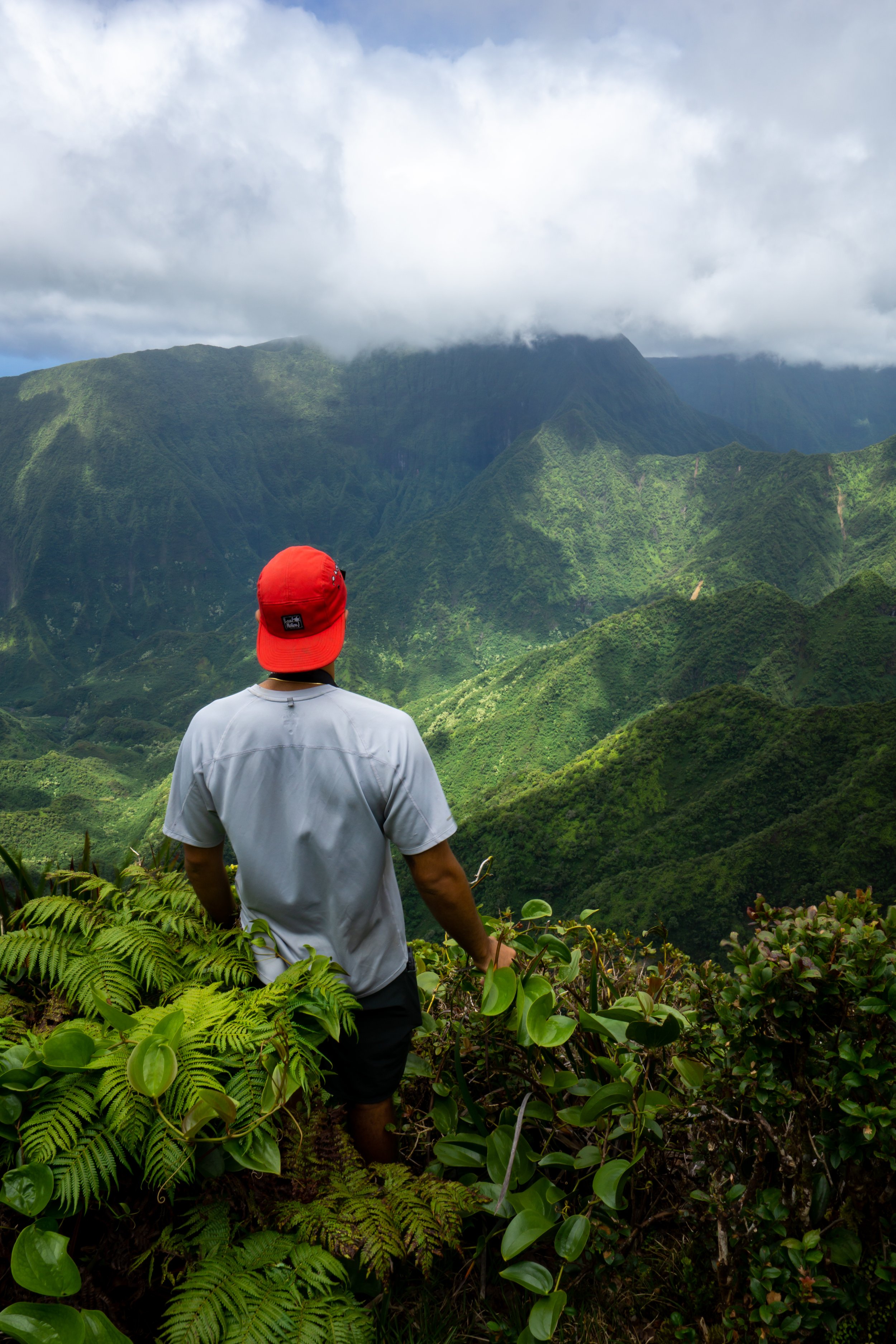
This photo is exactly why I recommend making the journey up here on the best weather days only. However, I’ve hiked the Pēpēʻōpae boardwalk a number of times and have always been lucky enough to see the view by being patient. To add to this, Hawaiʻi is typically wetter, meaning cloudier in the winter and drier in the summer. But, clear and cloudy days can truly happen at any time.
On this particular day, I only had to wait about 20 minutes for the clouds to clear before Pelekunu Valley opened up, which is one of the most mind blowing views across all the Hawaiian Islands!
Furthermore, the rest of my favorite hikes in Hawaiʻi are all located on Kauaʻi.
Pelekunu Valley
I’m not kidding when I think that the Pēpēʻōpae Bog is one of the best trails in Hawaiʻi, and this photo doesn’t even come close to showing the scale of the massive, beautiful Pelekunu Valley along the North Shore of Molokai.
Native Plants on the Pēpēʻōpae Bog
As mentioned previously, the Pēpēʻōpae Bog is one of the most pristine native forests throughout all of Hawaiʻi, which is why I ask that you please do your part to minimize your impact on this beautiful native forest.
Furthermore, some of the plants that you can expect to see in this beautiful ʻŌhiʻa-dominated forest include Uluhe, Pilo, Akaʻawa, Kōlea, ʻUki Grass, ʻĀkala, ʻĀlaʻa, and Paʻiniu, to name just a few.
If you’re interested in learning more about these and tons of other native Hawaiian plants from across the islands, I encourage you to read more in my separate post linked below.
Read My Separate Post: Native Hawaiian Plant Guide
More Molokai Adventures
If you’re interested in reading about some more amazing Molokai adventures, check out my separate posts below!
Best Hotels & Vacation Rentals on Molokai
Although there aren’t a ton of places to stay on Molokai, I recommend starting your search on VRBO.
This way, you can compare options from all different sides of the island.
Best Way to Book Rental Cars!
I travel quite a bit, and I know firsthand that finding a good rental car deal can be a challenge, but that’s why I recommend comparing all of your options with Discover Cars.
In short, Discover Cars is a well-known, reputable business that allows you to search for the best deal across companies, and they have the best full-refund cancellation policy I’ve ever seen, valid up to 72, or sometimes even 48, hours prior to your reservation!
Book Here: Discover Cars
Visiting Other Islands
If you are visiting Molokai or heading to another island, check out some of my personal recommendations for Oʻahu, Maui, Kauaʻi, Molokai, Lānaʻi, and Hawaiʻi Island (Big Island) in these separate posts.
If you’re trying to decide which island is right for your visit, check out my overview about each island in the post below.
Read My Separate Post: What is the Best Hawaiian Island to Visit?
What is the Best Time of Year to Visit Hawaiʻi?
The weather in Hawaiʻi can often appear to be warm and beautiful throughout the year, but in my experience, there is a lot more to consider when planning what time of year to visit the islands, such as what island you are considering, what sides of each island do you plan to stay, what activities are you most interested in, the wildlife, and countless other nuanced variables that can all impact the type of trip you can expect to have.
For these reasons, I highly recommend reading through my separate article to not only understand my thoughts regarding the best time of year to come to Hawaiʻi but also what you need to consider based on the time of year that you plan to visit.
Read My Separate Post: What is the Best Time of Year to Visit Hawaiʻi?
Safety
All hikes in Hawaiʻi should not be compared to trails outside of the islands, and hikers should exercise due caution on every adventure, given that many are extremely dangerous.
By this, I mean that Hawaiʻi is known for hot, humid weather, steep, dramatic, and unstable cliffs, and flash floods, which can occur without warning. Therefore, it is important that you check the local forecast, understand the physical condition of your entire group, and pack sufficient food and water before attempting any adventure.
Disclaimer
All information provided on this blog is for informational purposes only and is not intended to be a substitute for information or advice from qualified professionals or managing agencies.
Noah Lang Photography LLC makes no representations or warranties regarding the accuracy or completeness of the information provided here, and readers should use their own discretion, judgement, and seek professional advice where it is appropriate.
Furthermore, Noah Lang Photography LLC shall not be held responsible for any injuries, lost individuals, or legal issues arising from the use of information provided on this website, and if applicable, the above safety disclaimer should be referenced to provide a generic overview of the risks involved.
All said, the content on this blog is for the sole use of Noah Lang Photography LLC, and unauthorized use or reproduction of this content is strictly prohibited.
Disclosure
This post is not sponsored.
However, some of the links in this post are affiliate links, which means that I may earn a small commission if a purchase is made through one of those links. This commission comes at no additional cost to you, and I only recommend products that I personally use and believe will add value to my readers. Thank you for your support, which enables me to continue creating more!
To read the full privacy policy, click here.

About This Blog
Noah Lang Photography, also known as @noahawaii, is 100% reader-supported!
I do not accept guest articles or sponsored content of any kind on my blog, which is why, if you enjoy the outdoor and travel content I create, please consider buying me a coffee!
I appreciate your support, which helps me continue to keep this blog alive!


