


Hiking Rim to Rim (Bright Angel to North Kaibab) in Grand Canyon National Park
Distance: 20.7 - 43.9 miles / 33.3 - 70.7 km
Hiking Rim to Rim in Grand Canyon National Park is one of the most sought-after bucket list hikes of any trail in the country! It’s one of the biggest names when it comes to overnight backpacking, and being the case, Rim to Rim permits are among the most competitive—similar to the Enchantments in Washington.
That being said, Rim to Rim is not as straightforward as it may sound. On account of overnight permits being so competitive, day hikers and backpackers piece together Rim to Rim in an endless variety of ways.
By this, I mean that booking Rim to Rim permits isn’t as cut and dry as simply securing one permit. Rather, backpackers can stay at as many or as few of the established campgrounds as they please, building an itinerary for Rim to Rim in whatever way makes the most sense for their group.
However, this inevitably means that finding consecutive overnight permits in the order and in the direction that you want to hike is one of the most challenging parts about planning Rim to Rim. In our case, we wanted to stay at every campground along the way, which is how we ended up starting at the Bright Angel Trailhead and finishing at the North Kaibab Trailhead.
Nevertheless, hikers piece together Rim to Rim in other ways because they either weren’t able to secure a certain campground, preferred to hike in a certain direction, did or did not want to use the Rim to Rim shuttle, or simply weren’t able to secure any permits. When I did the hike over Memorial Day weekend, there were a lot of day hikers and trail runners, far exceeding the number of backpackers, and that’s mostly because none of them were able to get a camping permit.
These are some of the many reasons why the distance above is so variable. On the short end, Rim to Rim on the Bright Angel to North Kaibab Trail is only 20.7 miles (33.3 km). However, Rim to Rim to Rim, utilizing both the Bright Angel and South Kaibab Trail, is roughly 43.9 miles (70.7 km).
All being said, my Rim-to-Rim experience may be identical or completely different to yours, but at the least, this article will help you understand what Rim to Rim is like if you choose to stay at each campground in the canyon like we did.
U.S. National Park Pass
Did you know that the same America the Beautiful Pass that grants access to all 63 U.S. National Parks can be purchased in advance at REI?
Yes, you can save time when you arrive by purchasing your National Park pass, along with your other outdoor gear, at REI before traveling to the park!


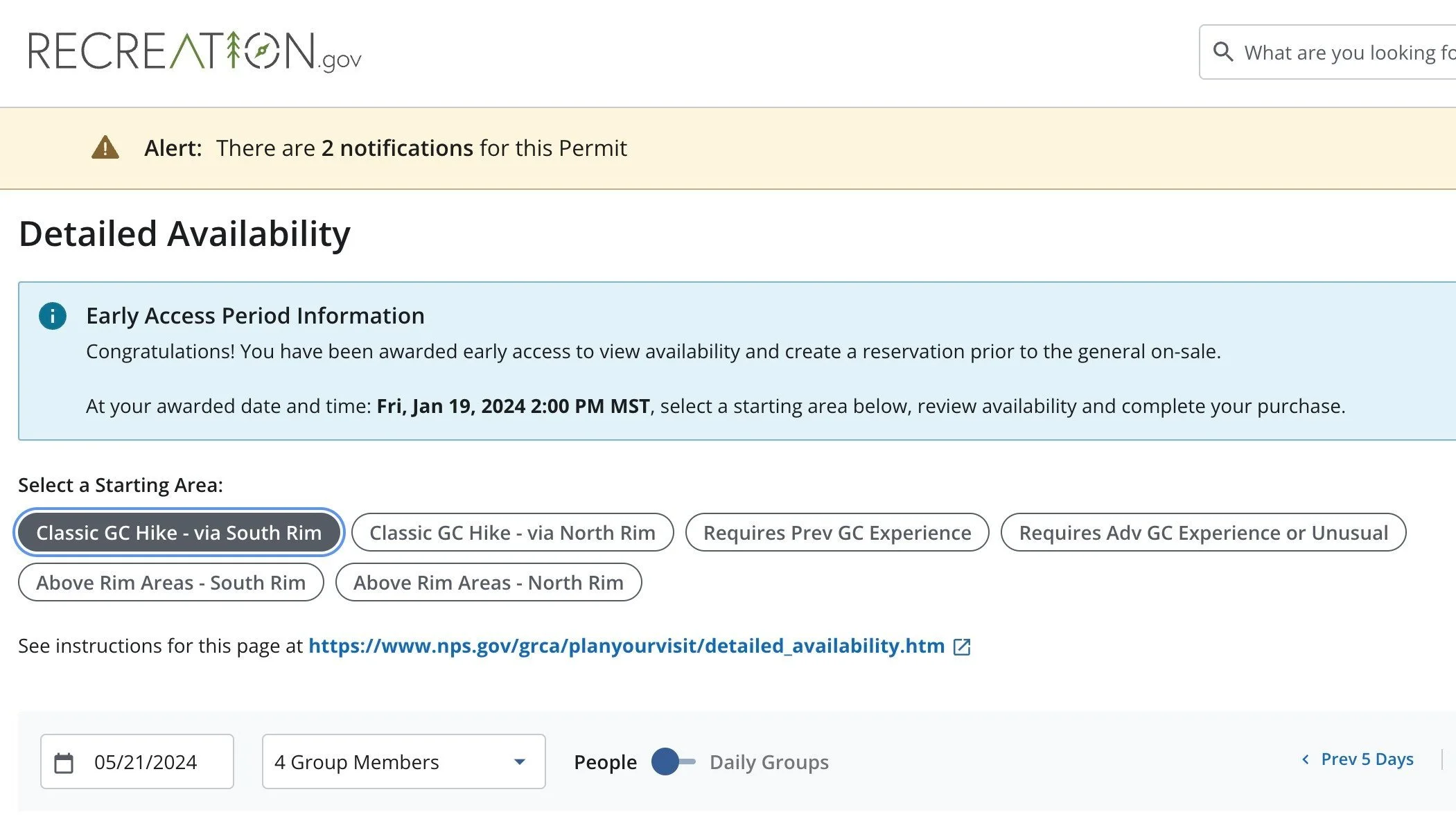
How to Get Rim to Rim Permits in Grand Canyon?
As previously mentioned, Rim to Rim is not a straightforward booking process.
Permits are reserved through Recreation.gov using the link below, but what makes Rim to Rim so challenging is the lottery system and the most ideal times of the year (not the summer months) being the most competitive regarding the number of applicants.
That being said, it’s important to follow along with the posted dates for each application period, and if you’re awarded an early-access time slot, to book yours on time!
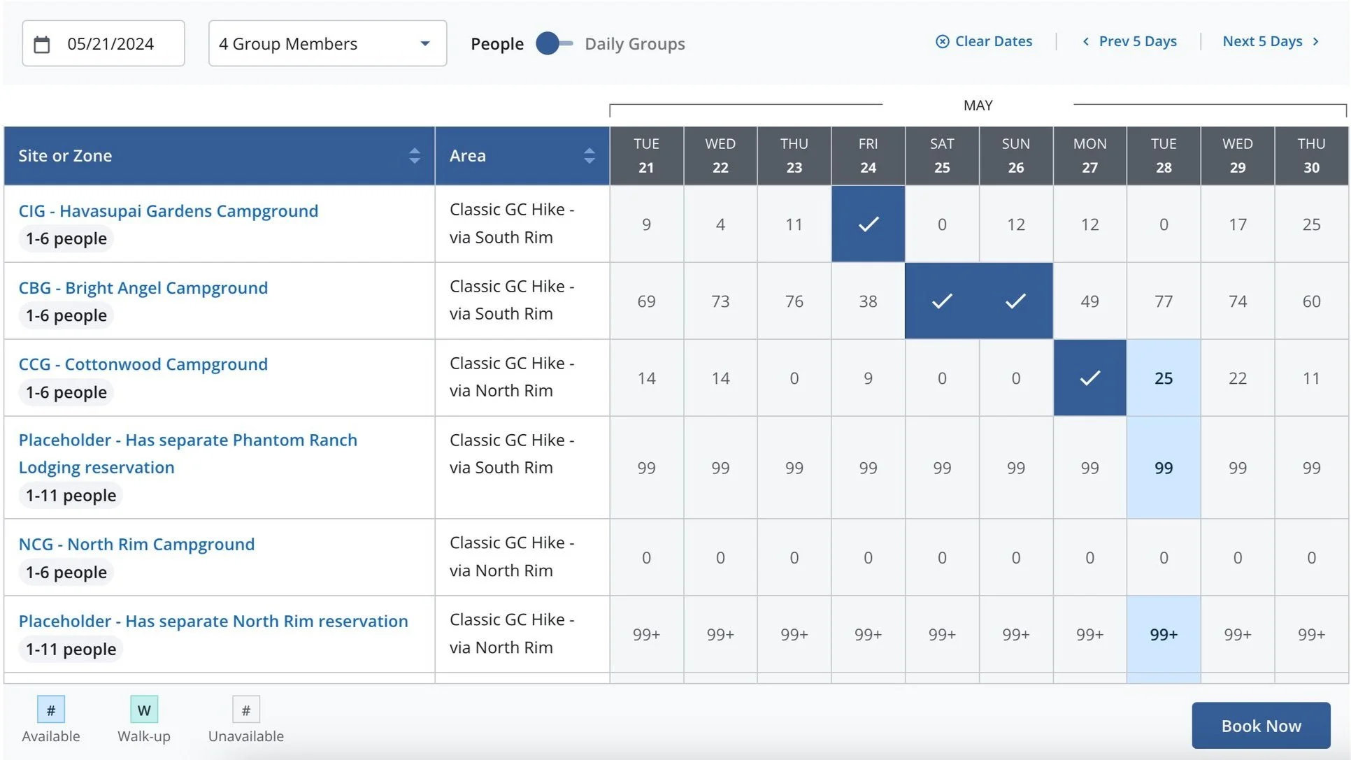
With all that in mind, the dates/ campgrounds that you want to book need to be available in consecutive order, like the photo below. If one of the checked dates didn’t have enough slots available, this itinerary wouldn’t have been possible. In addition, our group didn’t actually use my awarded date on January 19th to book our permits because a friend in the same group was awarded January 11th. This is how we were able to get Memorial Day, and by the time my awarded date on the 19th came around, most of May was already booked up.
This is all to say that hopefully one member of your group will be awarded an ideal time slot. If that doesn’t work, all unclaimed permits will be released to the general public after the early access period, which can be a good last resort!
Book Here: Grand Canyon Backcountry Permits
Rim to Rim Permits
Rim to Rim Permits
Rim-to-Rim Trailhead Parking
Depending on exactly which direction/ trailhead you choose to begin, parking can be at either one of a number of different areas.
That being said, trailhead parking on the North Rim is fairly straightforward, as there is only one place to go. However, trailhead parking in Grand Canyon Village on the South Rim for either the South Kaibab or Bright Angel Trailhead is much more confusing.
What I mean is that the National Park Service doesn’t have designated overnight parking for backpackers in Grand Canyon Village. In fact, trailhead parking on the South Rim is a bit of a free-for-all. If you call, they may even tell you that you’re more than welcome to park at the Backcountry Office, but the office is nowhere near either trailhead.
Therefore, you’re best off driving around to find as close a parking spot as you can find, with the best chances being early in the morning!
Google Maps Directions: Grand Canyon Village (South Rim) / North Kaibab Trailhead
Hiking Checklist - Grand Canyon
Obviously, for camping, you will need general backpacking gear. For this reason, I wrote a separate post about what backpacking gear is worth the money, from my experience, and what the best alternatives are to save you money.
Read My Separate Post: Best Ultralight Backpacking Gear
In addition, here is a complete list of must-have things that you will want for any hike in Grand Canyon National Park.
Osprey 3L Water Bladder - The Osprey 3L water bladder is the most universal hiking and backpacking water bladder on the market, and it’s my go-to because of the slide-off seal that allows it to be quickly filled from the top. Additionally, individual parts are easily replaceable, such as the bite valve.
Blister / Heel Protectors - I swear by these cheap, amazing heel protectors to prevent blisters for nearly every kind of hiking and backpacking that I do!
Black Diamond Headlamp - Personally, I recommend the Black Diamond Storm because it is one of the brightest, lightest, and longest-lasting headlamps on the market—and trust me, the weight-to-battery-life ratio really does matter!
Hiking / Trail Running Shoes - Depending on the type of trail, I prefer to use either the Keen Targhee for longer, more rugged hiking or the HOKA Zinal Trail-Running Shoe for lighter, less intense trails. In either case, both have been amazing to me for many years across countless environments, and both can be found in men’s and women’s sizes. - (Men’s Keen / Women’s Keen) (Men’s HOKA / Women’s HOKA)
Waterproof Rain Shell - You never know when it may rain, and I’ve learned over the years that a rain shell is far better than a rain jacket. By this, I mean that it’s best to have something that the water will roll right off of, which is why I recommend the Patagonia Torrentshell 3L available in both men’s and women’s sizes.
Sun Shirt w/ Hood - A quality sun shirt can be your best friend on a trail with minimal shade, which can be found in both men’s and women’s sizes.
High SPF Sunscreen - Packing high-SPF sunscreen is a must for long days outside!


Hiking the Rim-to-Rim Trail
Bright Angel Trailhead (South Rim)
As previously mentioned, our itinerary was to camp at least one night at each campground in Grand Canyon, which is why we began at the Bright Angel Trailhead.
Bright Angel-Rim Connector Junction
At this first split, go left to continue down the canyon.
The trail to the right is nothing more than a short connector to the Rim Trail up above.
From the trailhead to Havasupai Gardens, the Bright Angel Trail descends roughly 3,040 ft. (927 m) over the course of 4.5 miles (7.2 km).
Upper Bright Angel Tunnel
The Upper Bright Angel Tunnel always makes for a nice mental checkpoint that you’re getting close if you’re climbing back up to the South Rim.
On the way down, my friend and I ran into one of the many Grand Canyon volunteers, and we stopped to talk with him for a few minutes.
To my surprise, he was not only keeping track of the number of hikers he saw, but he said the pink counter was for "hikers with a bad plan!"
By this, he meant hikers going too far, starting too late, not carrying enough water, and not dressed appropriately, to name a few things. This is why it’s important to take the hiking checklist above seriously, but above all else, come prepared with a good water bladder! That and a hooded sun shirt may be the most important gear items that you can bring!


Lower Bright Angel Tunnel
The Lower Bright Angel Tunnel is about 1.0 mile (1.6 km) below the Bright Angel Trailhead.
1.5-Mile Resthouse
At about 1.5 miles (2.4 km), the Bright Angel Trail passes by the 1.5-Mile Resthouse.
That being said, it’s important to know which water stations are operational before hiking in Grand Canyon, as some can be out of service for a variety of reasons.
Therefore, be sure to read the trail updates put out by the National Park Service to learn more about which sources are and are not available.
National Park Service: Grand Canyon Trail Updates
Two-Mile Corner
Then, at almost exactly 2.0 miles (3.2 km), the Bright Angel Trail passes by an unofficial prominent switchback known as Two-Mile Corner.
This switchback is visible from hundreds of feet up, and it makes for a nice mental checkpoint to know how far you’ve walked or have to go.
Three-Mile Rest House
Compared to the 1.5-Mile Resthouse, the 3-Mile Resthouse is a bit more popular, as it is a popular turnaround point for day hikers on the Bright Angel Trail.
In any case, I encourage you to check out the beautiful Garden Canyon Overlook, located a short walk past the resthouse.
Garden Canyon Overlook
This is the Garden Canyon Overlook, where the Havasupai Gardens Campground can be seen off in the distance.
The campground is located where the large grouping of Cottonwood trees is concentrated at the bottom of the canyon.
Once back on the Bright Angel Trail, there is only another 1.5 miles (2.4 km) until the Havasupai Gardens Campground.
This section on the Bright Angel switchbacks was one of the more picturesque locations on the trail!
That being said, be sure to hike with a polarizer in order to cut through some of the harsh desert light in your photos.

At the bottom of the initial switchbacks, the Bright Angel Trail 'levels out' significantly compared to the beginning sections.
Havasupai Gardens Campground-Bright Angel Junction
Havasupai Gardens is the first and only campground on the Bright Angel Trail, where we reserved our first night before descending further.
Here, go left for the Havasupai Gardens Campground, or go right to bypass the campground and stay on the Bright Angel Trail.
Havasupai Gardens Campground-Ranger Station Junction
If you’re hiking through the campground, go right at the next split.
The trail to the left leads to the Havasupai Gardens Ranger Station.
Havasupai Gardens Campground
If this is your first time camping in Grand Canyon during the summer, it will quickly become apparent how the campsites with the best shade are the most desirable during the hot summer season.
Even in May, it was difficult and competitive to find good campsites, which is one of a few reasons why hiking early can be an advantage!
This is one of many water-filling stations found throughout Havasupai Gardens.
Honestly, not bad!
Unlike other backcountry areas in the Grand Canyon, the National Park Service provides storage boxes for your food on the highly-established Rim-to-Rim Trail.
With that in mind, these boxes aren’t for the bears, which are found almost exclusively in the upper elevations of the park. Rather, they are for squirrels, deer, and other hungry animals that can and will chew through tents, backpacks, and other gear items to get to your food!
That being said, it’s important to keep any scented items—including your clothes and backpacks—off the ground because squirrels will ruin your gear in a matter of seconds if you don’t!
It happened to one member in our group, where they chewed right through a backpack strap because of the sweat on it.
On the lower side of Havasupai Gardens, there are a number of places to check out before the trail reconnects with the Bright Angel Trail.
Bright Angel-Plateau Point Junction
At the very far end of Havasupai Gardens, the Bright Angel Trail splits, where the Plateau Point Trail begins.
With that in mind, go right to continue on the Bright Angel Trail to the Colorado River.
On day two, we started hiking at around 8 a.m., which would be a considerably late start if we were climbing up to the South Rim.
However, on these downhill days, the time we started wasn’t as crucial as the days we were ascending the North Kaibab Trail.
Bright Angel-Tonto East Junction
The East Tonto Trail is the only split in the Bright Angel Trail below Havasupai Gardens.
Here, go left to continue toward Pipe Creek Canyon and the Colorado River just beyond.
Garden Creek
The Bright Angel Trail crosses Garden Creek two different times, which can be one of the last reliable places to find water until the trail reaches the Colorado River at the bottom.
Pipe Creek Canyon
When the Bright Angel Trail reaches Pipe Creek Canyon, the views really begin to open up, which, in my opinion, was one of the most beautiful sections on the entire Rim-to-Rim Trail.
Pipe Creek
The bottom of the Pipe Creek switchbacks is where the Bright Angel Trail crosses the creek for the first time.
Eventually, Pipe Creek began to flow more than at the beginning, mostly due to Garden Creek and Pipe Creek coming together above this crossing.
Pipe Creek Shelter
Just before the Colorado River, the Bright Angel Trail passes by the Pipe Creek Shelter, located on the far side of Pipe Creek.
That being said, the Pipe Creek Shelter is the last shelter on the Bright Angel Trail before the Rim-to-Rim Trail crosses over the Colorado River.
Colorado River (Bright Angel-River Junction)
When Bright Angel Trail reaches the Colorado River, it officially turns into the River Trail, which is simply the section of trail that parallels the south side of the Colorado River from Pipe Creek Beach to the South Kaibab Trail near Kaibab Trail Suspension Bridge.
In any case, go right to continue toward the Bright Angel Campground and Phantom Ranch.
Sun Shirts
If this is your first time in the area, you’re likely unprepared for how strong the sun can be.
For this reason, I recommend picking up a quality, hooded sun shirt if you plan to do any hiking. Protection from the sun cannot be overstated, and in my experience, sunscreen alone has never been enough over a multi-day visit, especially if you’re visiting during the summer season!
Bright Angel Bridge (River Loop Trail)
After 1.5 miles (2.4 km), the River Trail meets the first of two bridges across the Colorado River: the Bright Angel Bridge.
With that in mind, I recommend hiking across both bridges on the River Loop Trail after setting up camp at Bright Angel, which you can learn more about below.
In any case, go left here to cross over the Bright Angel Bridge on the fastest route to both the campground and ranch.
Bright Angel Campground-North Kaibab Junction
This is the split that crosses over Bright Angel Creek to the North Kaibab Trail.
Here, go left to hike through the Bright Angel Campground, or go right to cross over Bright Angel Creek to begin the North Kaibab Trail.
I went to the left because we were staying at Bright Angel Campground.
Bright Angel Campground
In short, Bright Angel Campground is a 0.25-mile (0.4 km) campground that parallels Bright Angel Creek and the North Kaibab Trail on the far side.
Finding a campsite with good shade proved to be the most difficult at the Bright Angel Campground, being that it is the most popular campground on the entire Rim-to-Rim Trail.
This was the temperature midday over Memorial Day weekend!
North Kaibab Trail
This is where the trail through the campground meets back up with the North Kaibab Trail.
Here, go left to hike to Phantom Ranch, which is a great place to hang out during the heat of the day!
Phantom Ranch
At first, the North Kaibab Trail passes by the Phantom Ranch Ranger Station, which I recommend visiting to sign the hikers’ log inside.
At this split, go right to continue hiking through Phantom Ranch, or left to bypass the busier sections of the trail.
Phantom Ranch Canteen
The Phantom Ranch Canteen is truly one of the best places to hang out during the hotter summer months.
It is here where you can buy snacks, drink cold beer, mail a postcard, and borrow games while enjoying the shade under one of the many Cottonwood trees surrounding the canteen.
All said, be sure to hike in with cash in case—for some reason—cards aren’t being accepted.
Phantom Ranch Steak Dinner
The canteen is also where you have the opportunity to eat the famous Phantom Ranch steak dinner, but this needs to be reserved in advance, as seats are limited and typically sell out during the busiest hiking seasons.
That being said, we booked ours for our second night at Bright Angel because we thought it would be more rewarding further into the trip.
Book Here: Phantom Ranch Canteen Reservations
'Secret Beach' (Colorado River)
While not advised, swimming in the Colorado River or the Bright Angel Creek was easily the best way to cool off throughout the day!
'Secret Beach' in particular ended up being our favorite, especially as golden hour made the colors on the canyon walls come out toward sunset!
Then, later that night, as we were sitting around camp talking and playing games, this little visitor literally dropped into our campsite.
When I say 'dropped,' the snake literally slithered down the cliffs of the adjacent wall and hung out in our camp for at least 10-15 minutes before moving on!
That being said, this is the Grand Canyon Rattlesnake, which is endemic to Grand Canyon National Park—endemic meaning it is found nowhere else on earth! So, while this was quite the shock at first, it was a pretty cool wildlife encounter, to say the least!
River Loop Trail
On our second day at Bright Angel, we decided to hike the 1.3-mile (2.1 km) River Loop Trail in order to walk both bridges that cross the Colorado River.
River Loop-South Kaibab Junction
After 0.6 miles (1.0 km), the River Trail ends, where the South Kaibab Trail drops down to the Kaibab Trail Suspension Bridge.
Here, go left to hike back across the Colorado River.
Kaibab Trail Suspension Bridge
In my opinion, the Kaibab Trail Suspension Bridge was cooler than the Bright Angel Bridge because of the tunnel through the rock, but the Bright Angel Bridge had better views of the canyon.
River Loop-Boat Beach Junction
Just before completing the River Loop, the trail passes by Boat Beach, which is a very popular landing spot for those rafting the Colorado River, as well as a popular spot for campers to visit and enjoy the ice-cold waters of the Colorado River.
That being said, the National Park Service advises against swimming in the Colorado River because of the strong currents.
Bright Angel Campground-North Kaibab Junction
This is the same junction before the Bright Angel Campground shown previously, except this is on the North Kaibab side of Bright Angel Creek.
Phantom Ranch
After our second night, we woke up early to get a head start on the heat, especially because this was our first day making our way back up the canyon.
Bright Angel Canyon (North Kaibab Trail)
Upon leaving Phantom Ranch, the North Kaibab Trail begins a very gradual climb up Bright Angel Canyon, gaining roughly 1,540 ft. (469 m) from Phantom Ranch to Cottonwood Campground.
However, the elevation change is hardly noticeable for most of the hike because it is spread out over the course of 7.2 miles (11.6 km).
North Kaibab-Clear Creek Junction
The Clear Creek junction is the only split in the North Kaibab Trail before Ribbon Falls.
That being said, stay straight (left) to continue up Bright Angel Canyon.
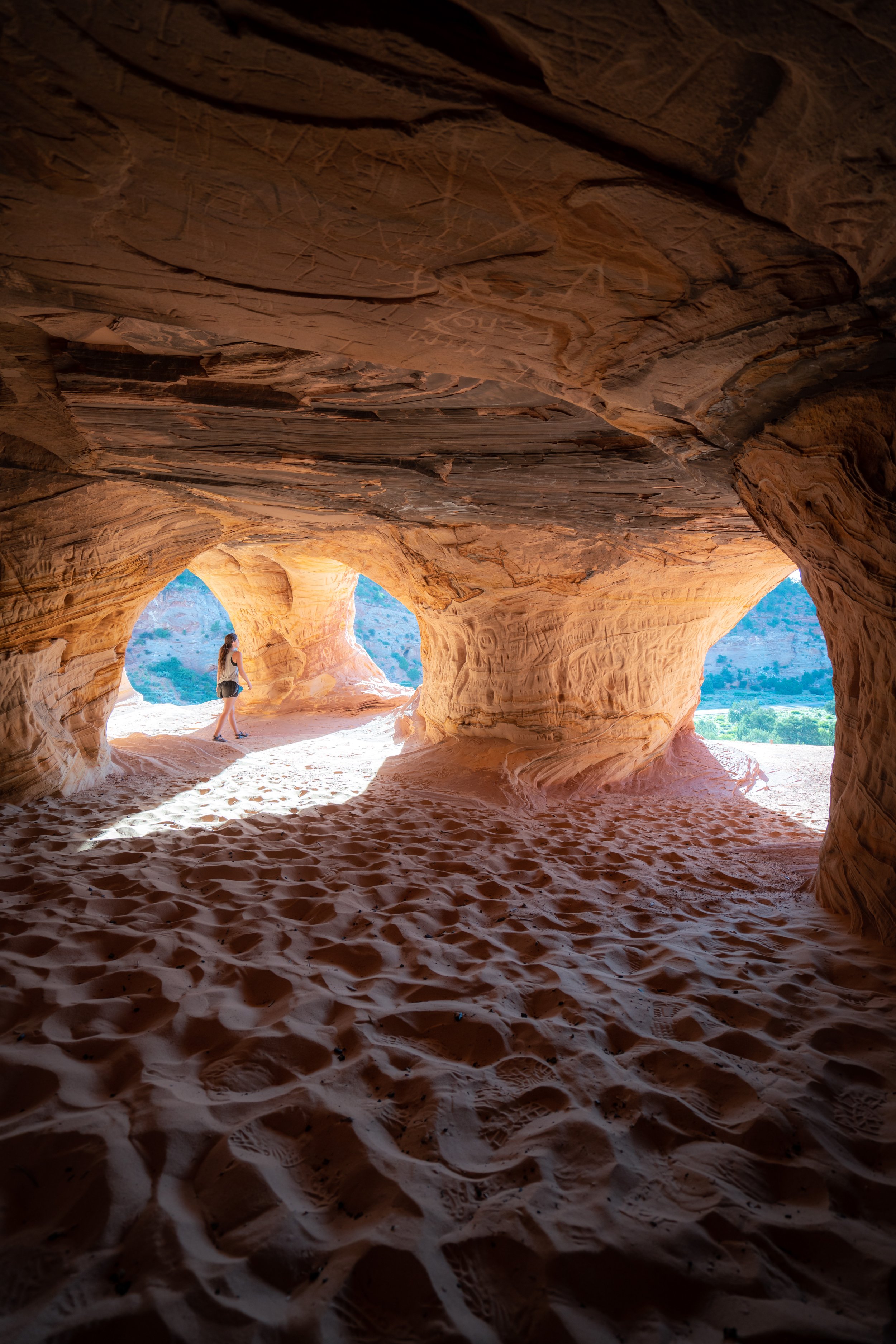
'The Box'
It was fairly universal that 'The Box', the section just north of Phantom Ranch, was one of the most beautiful parts of Bright Angel Canyon and the entire Rim-to-Rim Trail, similar to Pipe Creek Canyon on the south side.
To this point, I strongly believe that the entire North Kaibab Trail is prettier than the Bright Angel Trail, especially on the upper-elevation switchbacks past Cottonwood Campground.
Hikers are considered lucky to see Sacred Datura, as the flowers are known to open in the late afternoon/ evening and close by mid-morning the following day.
After about 4.2 miles (6.8 km), Bright Angel Canyon begins to open up, which is a nice sign that you’re getting closer to the first Ribbon Falls junction.
North Kaibab-Ribbon Falls Creek Junction
Whether you choose to visit Ribbon Falls via the Creek Trail and return to North Kaibab via the Bridge Trail, or hike to Cottonwood first and return later, I highly recommend visiting Ribbon Falls at some point during your hike!
We chose the latter of the two scenarios, which I preferred because we had it all to ourselves in the late afternoon when all the day hikers had cleared out.
In any case, go right to continue on the North Kaibab Trail toward Cottonwood Campground.
After the first Ribbon Falls junction, the North Kaibab Trail climbs a bit of an annoying hill before dropping down to the second Ribbon Falls junction.
North Kaibab-Ribbon Falls Bridge Junction
This is the second Ribbon Falls junction, and it’s the route we took later in the day to get to Ribbon Falls.
That being said, go right to hike the remaining 1.1 miles (1.8 km) to Cottonwood Campground.
Wall Creek
If you’re in need of water, I recommend passing by Wall Creek and continuing on to Cottonwood, unless it's an emergency.
I say this because a reliable water station can be found near the Cottonwood Ranger Station at the beginning of the campground, about 0.7 miles (1.1 km) away from Wall Creek.
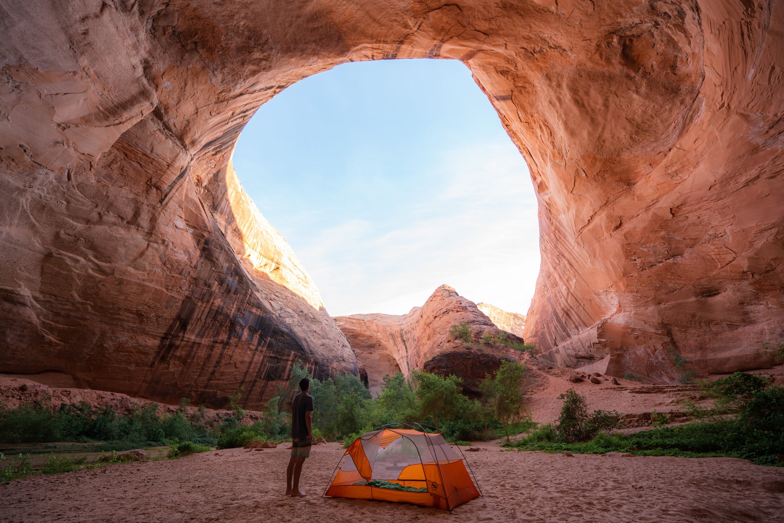
Cottonwood Campground
Cottonwood Campground is the final campground on the Rim-to-Rim Trail before the North Rim Trailhead, located about 6.5 miles (10.5 km) away.
With that in mind, Cottonwood was our least favorite campground, and in my experience, it was the least crowded of the three.
However, I’m happy that we stayed here because it allowed us to enjoy Ribbon Falls without the day hikers that we could see when we passed by early in the day.
If you walk down to Bright Angel Creek for a swim, remember to hang up your bags to prevent them from being damaged by the squirrels.
Bright Angel Creek
This was the little swimming hole that we enjoyed in the creek, as we waited for the sun to pass over before hiking back to Ribbon Falls.
Ribbon Falls Trail
Regardless of which junction you take to get to the Ribbon Falls Trail, the final stretch ends up being a fun little scramble to get up to the waterfall.
Ribbon Falls
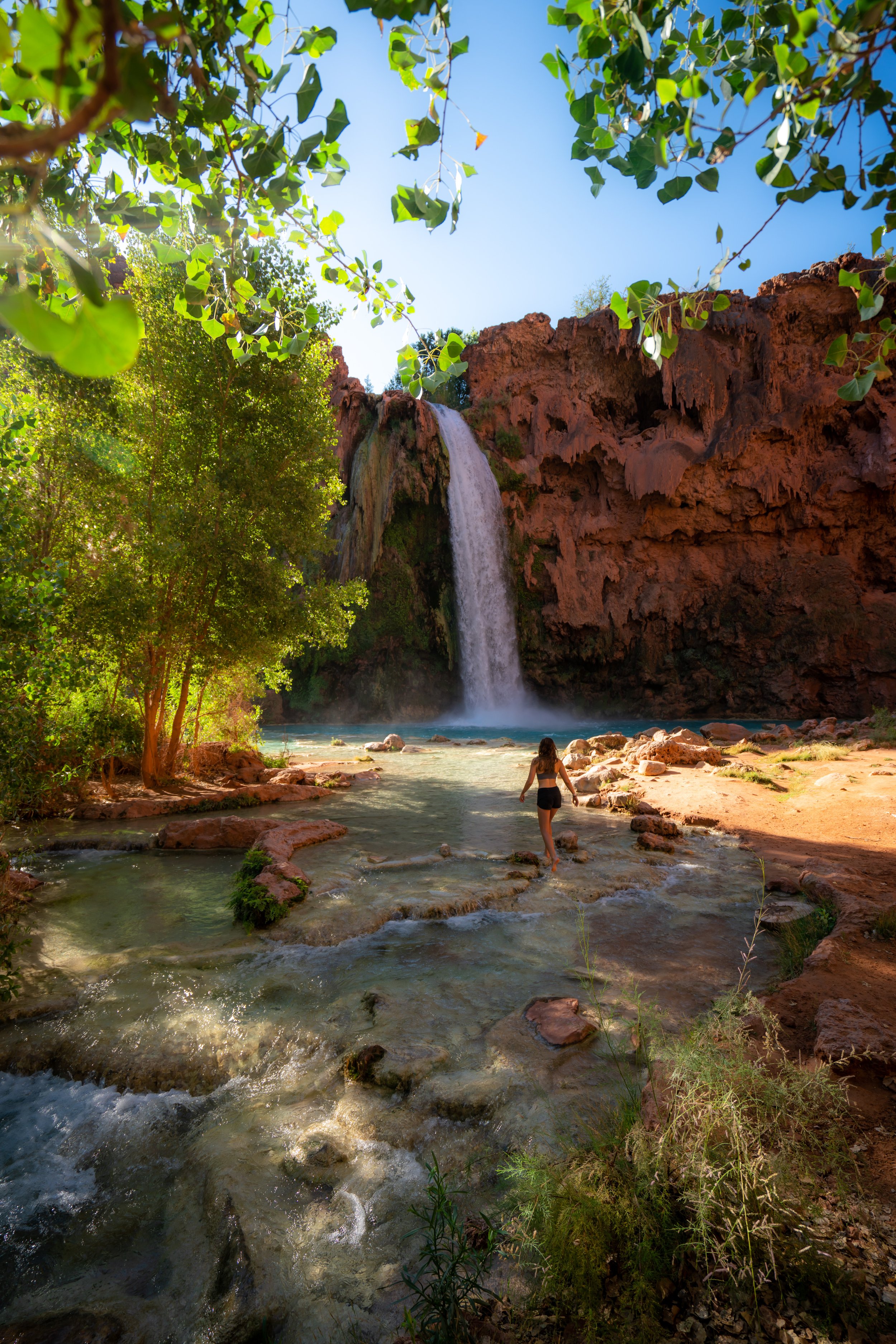
After only 0.3 miles (0.5 km) from either North Kaibab junction, the trail ends at the 100-ft. (30.5 m) Ribbon Falls, which, to me, made me think of my time at Havasupai, located further down the Grand Canyon.
In any case, I can confidently say that Ribbon Falls was much more beautiful than it appears from the North Kaibab Trail, and it was even better that we got to enjoy it all to ourselves!
Cottonwood Campground
The next morning, we got up the earliest we had all trip to begin hiking up to the North Rim.
In fact, we were even late compared to other groups leaving Cottonwood.
At first, the North Kaibab Trail simply continues up Bright Angel Canyon, but it isn’t until Manzanita that the elevation gain becomes much more noticeable.
First light was truly something to enjoy on both mornings that we hiked early up the North Kaibab Trail, but be sure to come prepared with a good headlamp for these early days!

Manzanita
In short, Manzanita is nothing more than a place to take a break and refill water.
It’s not a campground, but it is the signifier that the steeper climbing is about to begin.
With that in mind, there’s about 4,200 ft. (1,280 m) of climbing from the Cottonwood Campground to the North Rim, or about 3,840 ft. (1,170 m) from Manzanita.
North Kaibab-Roaring Springs Junction
After Manzanita, the Roaring Springs junction is the only split in the North Kaibab Trail before the North Rim.
That being said, go left to continue up to the North Rim, but you can see what the Roaring Springs Trail looks like from my photos below.
Roaring Springs Trail
Let’s just say, I hiked the Roaring Springs Trail, so that you don’t have to.
It was pointless; I thought there would be something to see, but just be happy that my curiosity saved you this 0.6-mile (1.0 km) roundtrip trek.
This is the end of the Roaring Springs Trail, and needless to say, it was pretty disappointing.
However, if you downstream to the waterfall, it may be better than simply hiking down to the creek.
North Kaibab-Roaring Springs Junction
Once back at the North Kaibab junction, I continued back up to the rim.
It was from here to the top that I finally began to hike in the sun.
This is where the North Kaibab Trail really begins to get pretty and bear a striking resemblance to somewhere in Zion National Park.
In total, there are 49 switchbacks, depending on how you count, from the Roaring Springs junction to the top of the North Rim.
With that in mind, they aren’t all at once, and only certain sections are more condensed, most notably the final sections following the Supai Tunnel.
Some of these sections along the edge are absolutely no-fall zones!
Roaring Canyon Bridge
It was sections like the Roaring Canyon Bridge that made the hike up the North Rim much prettier than the south, in my opinion.
Then, all of a sudden, this little Desert Centipede crossed right in front of me!
That being said, it’s important to leave them be because they are venomous and do bite humans!
Supai Tunnel
Located roughly 2.0 miles (3.2 km) below the North Kaibab Trailhead, the Supai Tunnel is one of the best mental checkpoints on the hike up to the North Rim.
At this split, go right to continue up to the North Rim.
In my experience, this is where the North Rim started to feel closer, as the white Coconino sandstone layer atop the North Rim is the last section to climb.
This is where the heat, at only 8:30 a.m., began to make the ascent feel more difficult than it would have been otherwise.
That being said, comments were made to our group like 'I wouldn’t want to be you' or 'I hope that camera was worth it,' referring to our climb back up the North Rim. However, I personally didn’t find the ascent to be all that difficult.
The only part that made it harder than it would have otherwise been was the mid-May heat, but other than that, the North Rim provided much more shade than the south, which is why I truly didn’t mind the extra elevation gain.
Nevertheless, hiking in a good sun shirt was the best thing I could have worn!
Coconino Overlook
Finally, the North Kaibab Trail passes by the Coconino Overlook, which is a popular day hiking destination for hikers visiting the North Rim.
It is here that you can see Humphreys Peak, the highest peak in Arizona, off in the distance on a clear day!
After the Coconino Overlook, there is only 0.7 miles (1.1 km) and 790 ft. (241 m) of climbing to reach the North Rim!
These Aspen trees were a nice sign that I was near the uppermost elevations of the trail.
This is the 49th and final switchback before reaching the top!
North Kaibab Trailhead (North Rim)
Finally, after about 30+ miles (48.3 km) of hiking, including separate day hikes, we finished on the North Rim after an enjoyable 5-day, 4-night trip from Bright Angel to North Kaibab.
I don’t think I would have planned it any other way, but I will be back in the future to hike the South Kaibab Trail on a separate trip.
On a different note, the Rim-to-Rim corridor in Grand Canyon National Park is one of the most manicured and commercialized 'backcountry' trips I’ve ever done. I say 'backcountry' because calling Rim to Rim backcountry is a bit loose in terms of what the word typically means.
That being said, I loved the entire experience, but it was a common sentiment among our group of five that we don’t see ourselves doing it again. Personally, I guess I just don’t like seeing an endless supply of other hikers, mostly day hikers, when I go into the backcountry, but I understand that I’m a bit spoiled after having other amazing backcountry experiences, like climbing Gannet Peak in the Wind River Range.
I know that largely had to do with the fact that our permits were over Memorial Day weekend, but nonetheless, I have to imagine that the trail can be just as busy throughout the cooler months of the year.
In any case, we booked the North-to-South Rim shuttle to get back to Grand Canyon Village, in which the afternoon pickup seemed to be the most popular option for backpackers. With that in mind, I highly recommend making your pickup location the North Grand Canyon Lodge if you plan to make it to the trailhead in the morning before the scheduled pickup time. It’s a much better place to get some food and kill a few hours compared to the trailhead, which you can hopefully hitch a ride over to like we did!
More Southwest Adventures
If you’re interested in reading about some more amazing Southwest adventures, check out my separate posts below!


Best Way to Find Places to Stay!
Wherever I travel, I love to start my search for places to stay on VRBO.
Even if I don’t end up booking through them, I think it’s one of the best ways to see what’s in the area!

Washington
Best Way to Book Rental Cars!
I travel quite a bit, and I know firsthand that finding a good rental car deal can be a challenge, but that’s why I recommend comparing all of your options with Discover Cars.
In short, Discover Cars is a well-known, reputable business that allows you to search for the best deal across companies, and they have the best full-refund cancellation policy I’ve ever seen, valid up to 72, or sometimes even 48, hours prior to your reservation!
Book Here: Discover Cars

Discover Cars!
Safety
Grand Canyon National Park is a place known for its extremes.
From the snow that blankets the upper elevations during the winter to extremely dangerous summer temperature differences that vary widely based on elevation, Grand Canyon National Park truly experiences it all.
By this, I mean that some of the most obvious dangers involve the risk of falling due to the steep and dramatic landscape, but some of the not-so-obvious risks have to do with black ice, wildlife, and summer temperature differences that often vary by as much as 30° F (17° C) from the canyon rims to Phantom Ranch at the bottom.
Furthermore, Grand Canyon National Park is home to a variety of wildlife, including bears, elk, bison, mountain lions, and seven venomous reptiles: six rattlesnake species and the Gila Monster.
Finally, lightning in upper-elevation areas, like Grand Canyon National Park and countless others across the West, can be particularly dangerous in the summer when monsoonal thunderstorms sweep across the canyon.
As always, find the most up-to-date information and conditions on the official National Park website.
National Park Service: Grand Canyon National Park
U.S. National Parks Pass
Did you know that the same America the Beautiful Pass that grants access to all 63 U.S. National Parks can be purchased in advance at REI?
Yes, you can save time when you arrive by purchasing your National Park pass, along with your other outdoor gear, at REI before traveling to the park!
More U.S. National Parks
If you’d like to read more about some of my best recommendations when visiting other U.S. National Parks, check out some of my other posts below!


Disclaimer
All information provided on this blog is for informational purposes only and is not intended to be a substitute for information or advice from qualified professionals or managing agencies.
Noah Lang Photography LLC makes no representations or warranties regarding the accuracy or completeness of the information provided here, and readers should use their own discretion, judgement, and seek professional advice where it is appropriate.
Furthermore, Noah Lang Photography LLC shall not be held responsible for any injuries, lost individuals, or legal issues arising from the use of information provided on this website, and if applicable, the above safety disclaimer should be referenced to provide a generic overview of the risks involved.
All said, the content on this blog is for the sole use of Noah Lang Photography LLC, and unauthorized use or reproduction of this content is strictly prohibited.
Disclosure
This post is not sponsored.
However, some of the links in this post are affiliate links, which means that I may earn a small commission if a purchase is made through one of those links. This commission comes at no additional cost to you, and I only recommend products that I personally use and believe will add value to my readers. Thank you for your support, which enables me to continue creating more!
To read the full privacy policy, click here.

About This Blog
Noah Lang Photography, also known as @noahawaii, is 100% reader-supported!
I do not accept guest articles or sponsored content of any kind on my blog, which is why, if you enjoy the outdoor and travel content I create, please consider buying me a coffee!
I appreciate your support, which helps me continue to keep this blog alive!