


Hiking the Sacred Rim Trail in Pinedale, Wyoming
Distance: 3.7 miles / 6.0 km
The Sacred Rim Trail is arguably the best day hike across the entire Wind River Range, and it’s easily one of the best outside of Yellowstone and Grand Teton National Park.
Personally, I love making the Sacred Rim Trail a sunset hike, but that’s not without saying that you need to come prepared for the mosquitoes! The Wind Rivers are notorious for having some of the worst mosquito conditions in all of Wyoming, but I wouldn’t let that stop you from visiting this hidden gem!


Elkhart Trailhead Parking
Parking for the Sacred Rim Trail (Elkhart Trailhead) is located near the end of Skyline Drive, about a half-hour drive from Pinedale down below.
From experience, I have seen the Elkhart Trailhead nearly empty of all cars or as packed as you see here at the end of July during the most popular backpacking season. That being said, I took these photos when it was the best time of the year to climb Gannett Peak.
Google Maps Directions: Elkhart Trailhead
Hiking Checklist - Wind River Range
Here is a complete list of must-have things that you will want for any hike in the Wind River Range.
Bear Spray & Holster - If you aren’t flying, don’t rent bear spray! It’s a waste of money. Prepare ahead of time by buying your own, as this may be one of the most important items on this list.
Osprey 3L Water Bladder - The Osprey 3L water bladder is the most universal hiking and backpacking water bladder on the market, and it’s my go-to because of the slide-off seal that allows it to be quickly filled from the top. Additionally, individual parts are easily replaceable, such as the bite valve.
Black Diamond Headlamp - Personally, I recommend the Black Diamond Storm because it is one of the brightest, lightest, and longest-lasting headlamps on the market—and trust me, the weight-to-battery-life ratio really does matter!
Hiking / Trail Running Shoes - Depending on the type of trail, I prefer to use either the Keen Targhee for longer, more rugged hiking or the HOKA Zinal Trail-Running Shoe for lighter, less intense trails. In either case, both have been amazing to me for many years across countless environments, and both can be found in men’s and women’s sizes. - (Men’s Keen / Women’s Keen) (Men’s HOKA / Women’s HOKA)
Blister / Heel Protectors - I swear by these cheap, amazing heel protectors to prevent blisters for nearly every kind of hiking and backpacking that I do!
Waterproof Rain Shell - You never know when it may rain, and I’ve learned over the years that a rain shell is far better than a rain jacket. By this, I mean that it’s best to have something that the water will roll right off of, which is why I recommend the Patagonia Torrentshell 3L available in both men’s and women’s sizes.
High SPF Sunscreen - Packing high-SPF sunscreen is a must for long days outside!


Hiking the Sacred Rim Trail
Beginning from the Elkhart Trailhead, the hike to Sacred Rim is fairly easy, as there’s only about 600 ft. (183 m) of elevation to gain over the course of 1.8 miles (2.9 km).
The trail aside, the most challenging part about the hike is the mosquitoes during the summer, meaning that you’ll want to hike in long sleeves and pants because of how bad they can be.
In any case, go left at the initial trailhead junction for the Pole Creek Trail and Sacred Rim.
Sacred Rim Junction
There is only one important turn to look out for on the entire hike, which is this unmarked split you see in the photo below.
Here, go left to continue hiking toward Sacred Rim. If you miss the turn, the trail to the right will lead deep into the Bridger Wilderness and not connect with Sacred Rim in any way.
After the split, the trail will continue through the Lodgepole forest, gaining elevation gradually on the way out to Sacred Rim.
Furthermore, I said that this trail was fairly easy in the beginning because the elevation gain is not very significant over this distance.
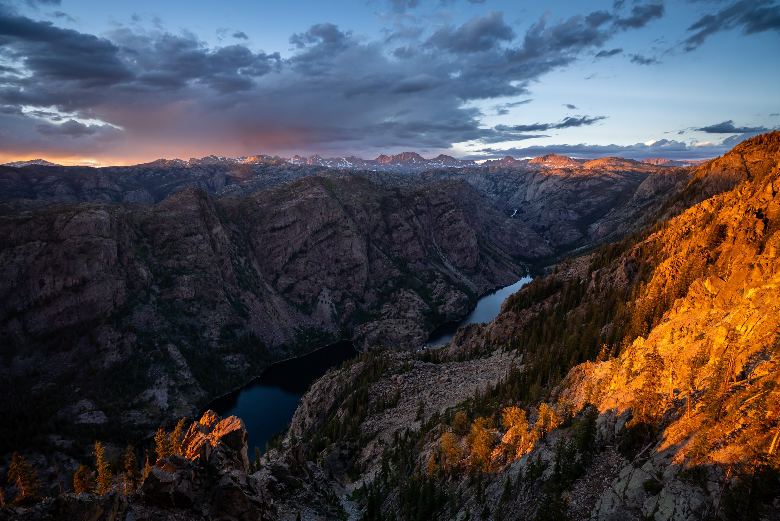
Sacred Rim
At the end of the trail, Sacred Rim opens up to this beautiful and dramatic drop-off, overlooking the Wind River Range to the east!
Overall, Sacred Rim is one of those hikes where you have no idea how amazing it’s going to be until you’re at the very end. With that in mind, the views of the Wind River Range are pretty spectacular, especially if you catch them on a clear sunset like we did.
Warning
Afternoon thunderstorms in high Mountain West areas, such as this, are a serious concern during the summer monsoon season.
Even if the weather forecast doesn’t predict any storms, I can tell you from personal experience that they may show up out of nowhere and can put you and your entire group in a very dangerous situation.
I say this to emphasize the importance of turning around at the first sign of lightning, thunder, or even heavy cloud buildup. However, if you ever get caught in a storm unsuspectingly, follow the steps linked below to reduce the risk of getting struck.
U.S. Forest Service: Lightning Safety Tips
How Bad are the Mosquitoes?
If this is your first trip to Wyoming, you’re likely unfamiliar with how bad the mosquitoes will be. Locals don’t joke when they call the mosquito the Wyoming state bird, which is why I recommend grabbing this cheap bug net before going. You never know where and when you may want it because even midday in the most unsuspecting places, the mosquitoes can be out in clouds!
My Print - Sacred Rim Sunset
Gannett Peak
It is my understanding that you can’t see Gannett Peak, the tallest peak in Wyoming, from the Sacred Rim viewpoint. In the future, I’ll have to go back and look for it after having climbed the peak in 2023.
That being said, if you’re curious about what it takes to climb the hardest highpoint in the lower 48, I encourage you to check out my separate article, as one of the more common approaches up Gannett begins from the same Elkhart Trailhead as Sacred Rim.
Read My Separate Post: Gannett Peak (Titcomb Basin)
More Nearby Adventures
If you’re interested in reading about some more amazing adventures nearby, check out my separate posts below!


Best Way to Find Places to Stay!
Wherever I travel, I love to start my search for places to stay on VRBO.
Even if I don’t end up booking through them, I think it’s one of the best ways to see what’s in the area!

Washington
Best Way to Book Rental Cars!
I travel quite a bit, and I know firsthand that finding a good rental car deal can be a challenge, but that’s why I recommend comparing all of your options with Discover Cars.
In short, Discover Cars is a well-known, reputable business that allows you to search for the best deal across companies, and they have the best full-refund cancellation policy I’ve ever seen, valid up to 72, or sometimes even 48, hours prior to your reservation!
Book Here: Discover Cars

Discover Cars!
Safety
It is widely known that Grizzly Bears dominate the greater Yellowstone-Teton area in northwest Wyoming, including the Wind River Range. However, as of 2024, Grizzlies have now been confirmed in Wyoming’s central Bighorn Mountains.
Therefore, it’s important to hike with bear spray and know how to react in the event of a Black or Grizzly Bear encounter, as their ranges only seem to be expanding across states like Washington, Idaho, Montana, and Wyoming.
Aside from wildlife, Wyoming, like any Mountain West state, is known for its violent afternoon thunderstorms, which are more typical in the warmer summer months than other times of the year.
That said, it’s important to check the local forecast before setting off on any adventure, as lightning strikes are not uncommon in and near mountain ranges across the West. I have personally been knocked to the ground by a strike that hit near me in the past, and I confidently say that it’s an experience you don’t want to live through. This is why I highly recommend checking Mountain Forecast for any high-elevation adventures you may be interested in—especially when climbing a summit.
Finally, Wyoming is one of the more glaciated states in the lower 48, and I say this to remind that all skills related to glacier travel are necessary whenever attempting an adventure as such.


Disclaimer
All information provided on this blog is for informational purposes only and is not intended to be a substitute for information or advice from qualified professionals or managing agencies.
Noah Lang Photography LLC makes no representations or warranties regarding the accuracy or completeness of the information provided here, and readers should use their own discretion, judgement, and seek professional advice where it is appropriate.
Furthermore, Noah Lang Photography LLC shall not be held responsible for any injuries, lost individuals, or legal issues arising from the use of information provided on this website, and if applicable, the above safety disclaimer should be referenced to provide a generic overview of the risks involved.
All said, the content on this blog is for the sole use of Noah Lang Photography LLC, and unauthorized use or reproduction of this content is strictly prohibited.
Disclosure
This post is not sponsored.
However, some of the links in this post are affiliate links, which means that I may earn a small commission if a purchase is made through one of those links. This commission comes at no additional cost to you, and I only recommend products that I personally use and believe will add value to my readers. Thank you for your support, which enables me to continue creating more!
To read the full privacy policy, click here.

About This Blog
Noah Lang Photography, also known as @noahawaii, is 100% reader-supported!
I do not accept guest articles or sponsored content of any kind on my blog, which is why, if you enjoy the outdoor and travel content I create, please consider buying me a coffee!
I appreciate your support, which helps me continue to keep this blog alive!